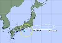
Tropical Storm Peipah moved eastward along Japan's Pacific coast on Friday, bringing heavy rains to Shizuoka Prefecture.
Linear precipitation zones, or strings of rain clouds that often bring torrential rain, formed in Shizuoka and Kanagawa Prefecture. Hourly rainfalls of 110-120 millimeters were reported at multiple locations in Shizuoka.
A man in his 80s in Hamamatsu, Shizuoka Prefecture, is believed to have fallen in a waterway.
In Makinohara, also in Shizuoka Prefecture, a large bus overturned and utility poles collapsed due to strong winds. Six houses were completely destroyed and 34 houses were partially damaged. Twenty-three people were injured.
High-speed train services were suspended for hours in some sections of the Tokaido Shinkansen line due to heavy rains.
Earlier, rainfall reached some 100 millimeters in one hour through 4 a.m. Friday near the town of Onagawa, Miyagi Prefecture. The village of Shimokitayama in Nara Prefecture recorded rainfall of 84.5 millimeters in one hour until 2:50 a.m. and 267 millimeters in the 12 hours through 9:20 a.m.
A maximum instantaneous wind speed of 94 kilometers per hour was logged at Cape Muroto in the city of Muroto in Kochi Prefecture past 4:40 a.m.


With your current subscription plan you can comment on stories. However, before writing your first comment, please create a display name in the Profile section of your subscriber account page.