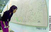
An exhibition of Japan's first maps based on an actual coastal survey by Ino Tadataka, a surveyor in the Edo Period, opened Wednesday at the Tokyo Big Sight exhibition hall in the Odaiba district.
The event showcases copies discovered last year in the United States of 207 of Ino's maps, which were drawn some 200 years ago, its organizers said.
Visitors can compare Ino's maps and the surveying instruments of his day to those of 100 years ago and of the present, they said.
Ino was known to have drawn 214 maps, although all of them disappeared during the Meiji and Taisho eras.
A project to remake the maps, based on the copies, is now under way so they will be able to be exhibited on a large scale, the organizers said.
Admission is free to the exhibition, which is scheduled to run until Friday.
Ino was born in 1745 in Chiba Prefecture and died at the age of 73 before completing his maps. His friends and pupils took over his work and completed them in 1821.


With your current subscription plan you can comment on stories. However, before writing your first comment, please create a display name in the Profile section of your subscriber account page.