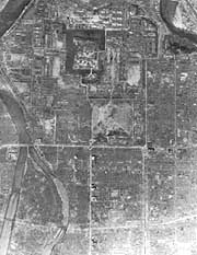
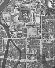
The Geographical Survey Institute has obtained 115 highly detailed aerial images of Hiroshima just days before and after it was hit by a U.S. atomic bomb on Aug. 6, 1945.
The images are clear enough to identify even small structures, institute officials said. Experts say the photos are valuable in painting a clearer picture of the atomic bombing and the damage it caused.
The institute obtained the negatives in March from the U.S. National Archives and Records Administration in College Park, Md. The photos were taken in 1945 on July 25, and Aug. 7, 8 and 11.
The negatives, focusing on the atomic bombing of Hiroshima on Aug. 6, 1945, may have been shot at low altitude, the officials said.
The images are expected to play a key role in calculating the amount of radiation inflicted based on distances from the hypocenter, said Norihiko Hayakawa, a professor with Hiroshima University's Research Institute for Radiation Biology and Medicine.
The Geographical Survey Institute, based in Tsukuba, Ibaraki Prefecture, is a national surveying and mapping organization of the Land, Infrastructure and Transport Ministry.


With your current subscription plan you can comment on stories. However, before writing your first comment, please create a display name in the Profile section of your subscriber account page.