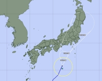
Tropical Storm Yun-yeung is forecast to approach the Tokai and Kanto regions on Friday afternoon, with a possible landfall bringing heavy rain across a wide area.
The storm is likely to move through the Tohoku region over the weekend, according to the Japan Meteorological Agency. It is not forecast to strengthen into a typhoon.
The weather agency has warned of heavy rain and strong winds, with forecasts expecting up to 250 millimeters of accumulation in the Kanto-Koshin region, including the Izu Islands, and 300 millimeters in the Tokai region in the 24 hours through 6 p.m. Friday. Warning-level rain is expected for the Tokyo area on Friday.
A linear precipitation zone — bands of dense clouds that can either move through or become stationary in a concentrated area and unload heavy rainfall —- may form near the Izu Islands from Thursday evening into Friday morning. The Meteorological Agency has warned of disasters related to heavy rain, such as landslides and flooding of low-lying areas.
The Meteorological Agency has also warned of lightning and the risk of tornadoes, as well as strong winds and high waves throughout Thursday and Friday near the islands as well as the Tokyo area.
As the storm approached Japan from the south on Thursday, JR East and JR Central announced that service delays and suspensions could occur depending on the storm’s path and impacts, adding warnings of possible cancellations for certain sections and lines.
Yun-yeung follows Typhoons Khanun and Lan, which tore through various parts of southern Japan last month.


