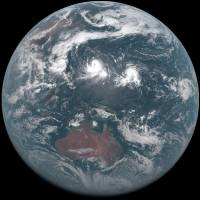
The world's first geostationary weather satellite capable of taking images in full color began regular operation Tuesday, with scientists hopeful it will help forecast typhoon movements and heavy rainfall.
Japan's Himawari-8, placed in a geostationary orbit about 36,000 km above the equator, can shoot 16 different kinds of images. Its closest predecessor, the Himawari-7, produces only five, the Meteorological Agency said.
The images are also higher resolution, allowing observation of an area as small as 500 sq. meters. The new satellite generates about 50 times the volume of data compared with the output of Himawari-7, the agency said.
The Himawari-8 can take images of the entire planet — within view of its geostationary position — every 10 minutes, compared with every one hour for the previous model, and can cover all of Japan in 2.5 minute intervals, compared with 30 minutes previously, the weather agency said.
Images taken during a test run Monday clearly showed three typhoons south of the Japanese archipelago.
Observation data obtained by the Himawari-8 is downloaded at an antenna site in Saitama Prefecture and transferred to a data center in Itabashi Ward, Tokyo, which will then process it and send it to the agency for weather forecasts and other uses.
The entire cost of the project is about ¥85 billion, according to the agency.
The Himawari-8 was launched in October to replace the Himawari-7, which was launched in February 2006 and remains operational. The older bird will now serve as a backup until the Himawari-9 is launched in fiscal 2016.


