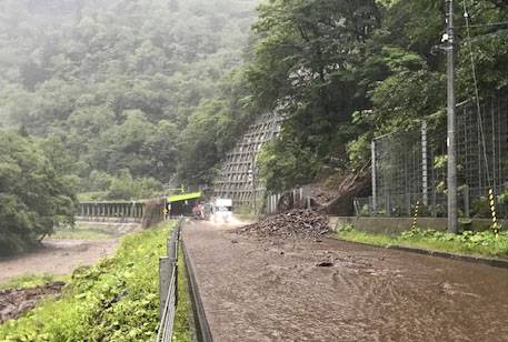
Heavy rain is expected to fall again in parts of Japan through Thursday with coastal regions in the north and west at particular risk of landslides and flooding, the country's weather agency said.
The agency called for vigilance as a front extending from a low pressure system is forecast to move south toward areas facing the Sea of Japan, warning of highly unstable atmospheric conditions that could lead to lightning and tornados.
The front is expected to move from northeastern Japan through Wednesday before heading toward the west on Thursday, colliding with warm, humid air and creating unstable atmospheric conditions, the Meteorological Agency said.
Heavy rainfall exceeding 40 millimeters per hour was recorded Tuesday in Hokkaido, with torrential downpours of over 80 mm in an hour possible, the agency said.
About 9,200 residents from 4,900 households in Hokkaido were asked to evacuate through the afternoon, with about 60 major roads closed.
According to the 24-hour forecast into Wednesday morning, 200 mm of rain was expected in the Hokuriku region, 180 mm in Tohoku, 150 mm in Hokkaido, and 120 mm in the Kinki, Chugoku and northern Kyushu regions.
The subsequent 24-hour forecast predicted 100 to 200 mm of rain in Hokuriku and Chugoku, 100 to 150 mm in Kinki and northern Kyushu, and 50 to 100 mm in Tohoku.