The Japan Aerospace Exploration Agency launched a satellite Saturday to improve car navigation and other services using the global positioning system.
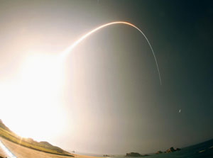
JAXA launched the quasizenith satellite Michibiki at 8:17 p.m. from the Tanegashima Space Center in Kagoshima Prefecture, using an HIIA rocket.
The 4-ton Michibiki, measuring 3 meters long, 3 meters wide and 6 meters high, is intended to boost the accuracy and coverage of GPS services in the country by complementing a U.S. satellite network.
The nation's GPS services currently depend on U.S. satellites that orbit not only above Japan and whose radio waves can be hampered by skyscrapers and mountains.
The agency aims to eliminate such blind spots and reduce the margin of error to within 1 meter by putting the Michibiki on an orbit almost just above Japan.
However, as the Michibiki will orbit above the country for only eight hours a day, two additional satellites are needed to provide 24-hour coverage.
The government has yet to draw up a specific launch plan for the additional satellites. It is expected to work out outline plans by next spring.
The government has so far earmarked about ¥40 billion as development costs for Michibiki and some ¥33.5 billion as ground facility and launch costs.