With hurricane season just a week away and a very active season predicted by meteorologists, thoughts are on what happened last year, when a tropical cyclone named Sandy raced north from the Caribbean, hung a sharp left off the mid-Atlantic coast and smashed into New Jersey and New York, killing 147 people, flooding some of the most valuable real estate in America and causing tens of billions of dollars in damage.
The summer and fall hold the possibility of big storms but also steps toward better forecasts. An infusion of Sandy-related dollars from Congress will help the National Weather Service upgrade two supercomputers that are used in virtually all U.S. weather predictions.
That, in turn, could close what some have called an embarrassing gap between the primary U.S. and European computer models. The European model has generally been more adept at forecasting the paths and intensities of major storms, and that pattern held last October when the European model projected the lethal westward turn by Sandy even as the early U.S. model showed it drifting to the east harmlessly, toward open ocean.
Beyond getting better at forecasts, government officials want to improve their communication skills. The National Oceanic and Atmospheric Administration (NOAA) recently released an after-action "service assessment" on Sandy that gave the National Weather Service a mixed review.
The report praises the NWS for its forecasts, noting that many days in advance the government warned decision-makers that they were facing an extremely dangerous storm that carried with it the potential for lethal storm surges. But the report concluded that the NWS was not always clear in its messages, and that the best information was often hard to root out on its website. A recurring complaint heard by the report's authors: "Too many clicks" were necessary to find out what was going on.
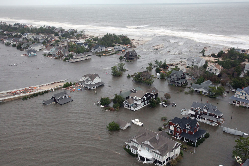
The result was, for many people, confusion. Many inhabitants of the East Coast were concerned about where the storm would make landfall but did not fully grasp how widespread the destruction would be, and how vulnerable they could be from the storm surge. Of the 147 people killed by Sandy, 49 drowned.
The storm came ashore near Brigantine, New Jersey, early in the evening of Oct. 29. But this was a monstrously vast weather event, with tropical-storm-force winds 1,500 km across. The effects were felt as far away as Wisconsin.
Sandy was dubbed a "superstorm" because the tropical cyclone collided with an intense low-pressure system rolling in from the west. That led to multiple feet of snow in the Appalachians. Sandy knocked out power to 8.5 million people, including most of lower Manhattan.
A good forecast is only a good forecast if it is communicated well and leads to good decisions by public officials and the general populace. That is the common thread linking most of the 23 recommendations of the NWS assessment.
The report recommends that the NWS develop "explicit storm surge graphics and high-resolution mapping tools" that better illustrate the storm surge threat.
Terminology is another problem. Weather service personnel used different points of reference in describing water levels. There was also confusion generated by a very basic meteorological fact: At some point, Sandy ceased to be a hurricane, as it spread out and became a massive nor'easter — still just as deadly. But that may have confused some people, who thought the danger had been diminished when Sandy was no longer technically a tropical storm. (Reflecting the storm's dual identity, the new NOAA report's title refers to "Hurricane/Post-Tropical Cyclone Sandy.")
Hurricane season officially begins June 1 and ends Nov. 30, with the great majority of storms (78 percent) forming from August to October. According to meteorologists who study conditions in the Atlantic basin, storm activity this season should be far above normal, with elevated chances of storms making landfall in the United States.
The source of most weather forecasts delivered on U.S. TV news and smartphones are supercomputers housed in Reston, Virginia, and Orlando, Florida. Congress has approved large parts of NOAA's spending plan under the Disaster Relief Appropriations Act of 2013 that will direct $23.7 million (or $25 million before sequestration), a "Sandy supplemental," to the NWS for forecasting equipment and computer infrastructure.
"This is a breakthrough moment for the National Weather Service and the entire U.S. weather enterprise in terms of positioning itself with the computing capacity and more sophisticated models we've all been waiting for," said Louis Uccellini, director of the Weather Service.
Last year, criticism began to emerge concerning the inferior accuracy of the NWS' Global Forecast System model — run on earlier versions of the supercomputers — compared with the model run at the European Center for Medium Range Forecasting, based in Britain. The GFS and ECMWF models are, by far, the most heavily relied on by meteorologists around the world for forecasting.
Cliff Mass, a professor of atmospheric sciences at the University of Washington and expert on numerical weather prediction, has called the standing of the GFS model "third-rate" and "a national embarrassment."
The $23.7 million in improvements to NWS' forecasting systems from the Sandy supplemental will facilitate a more than tenfold increase in the capacity of the supercomputer running the GFS model by the 2015 fiscal year.
"This is an extraordinarily positive development and will give the National Weather Service the potential to lead the world in numerical weather prediction," Mass wrote in an email.
The increased computing power will enable drastic improvements in the GFS model's resolution, Uccellini said. Higher resolution models pick up on weather features a lower resolution might miss, like some high-altitude steering currents.
The $23.4 million appropriated to the NWS for forecasting improvements is just a small fraction of the $309.7 million NOAA will receive as part of the Sandy relief legislation. For example, funds will support ocean observing and coastal monitoring, disaster assistance for fisheries and upgrades to two NOAA hurricane hunter aircraft, among other initiatives.
NOAA said that sequestration will not interrupt "mission critical" activities. It proposes agencywide furloughs — including forecasters — on July 5 and 19 and Aug. 5 and 30. But employees who work in offices that are staffed 24 hours a day would stagger their furlough days.